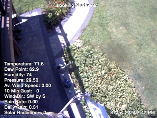
nws-alerts: Checking more than four warning/county codes can delay the loading of your pages. You should use a cron job to get the data.
No Warnings, Watches, or Advisories

Regional Radar Regional Infrared Satellite
Radar/Satellite images courtesy of Weather Underground.
spacer
Webcam Current Surface Map
Surface Map images courtesy of Weather Channel.
spacer
Updated: @ 12-Jul-2025 3:51pm  
Summary / Temperature Wind Rain Outlook
Mostly cloudy Mostly cloudy
Currently: 84.1, Max: 87.8, Min: 72.1 84.1°F
Colder 2.2°F than last hour.

Warm

Feels like: 89°F

24-hr difference
-1°FColder 1.0°F than yesterday at this time.
  Today Yesterday
High: 87.8°F
1:25pm
86.5°F
1:32pm
Low: 72.1°F
6:24am
70.5°F
6:30am
 Wind from SSE SSE
3
Gust:
9 mph
1 Bft - Light air
Today: 10 mph 3:36pm
Rain Today: 0 in
Rain Rate (/hr): 0 in
Rain Yesterday: 0 in
Storm Rain: 0 in
This Month: 0.64 in
Season Total: 18.65 in
2 days since last rain.
Tonight

Tonight: Mostly Cloudy
Mostly Cloudy
Humidity & Barometer Almanac Moon
Humidity: 65 % Increased 2.0% since last hour.
Dew Point: 71°F Decreased 1.2°F since last hour.
Barometer: 30.09 inHg  
Baro Trend: Steady
Sunrise: 5:30am
Sunset: 8:25pm
Moonset: 7:02am
Moonrise: 10:00pm
Waning Gibbous
Waning Gibbous, Moon at 16 days in cycle
96%
Illuminated
UV Index Forecast UV Index Forecast
12-Jul-2025
8.7     Very High 
13-Jul-2025
9.0     Very High 
 NWS Weather Forecast  - Outlook: This Afternoon & Tonight
This
Afternoon
This Afternoon: Mostly Sunny
Mostly Sunny

Hi 83 °F
NWS forecast: Mostly sunny. High near 83, with temperatures falling to around 81 in the afternoon. Southeast wind around 8 mph.
Davis VP+ forecast: Increasing clouds with little temperature change. Precipitation possible within 24 to 48 hours.
 
Tonight

Tonight: Mostly Cloudy
Mostly Cloudy

Lo 67 °F
NWS forecast: Mostly cloudy, with a low around 67. Southeast wind 3 to 8 mph.